Category Archive: Uncategorized

Beach fun in Kihei, Maui
Affordable Maui: Kihei has the budget restaurants, easy access beaches for picnics, swimming and snorkeling. Complete directions for locating all the fun is in the Maui Trailblazer guidebook. More island photos on the… Continue reading
Follow the Trailblazers
http://images.travelpod.com/bin/tripwow/flash/tripwow.swf The Hawaii Roadshow Slideshow: Hawaii’s trip from Austin, Texas, United States to 12 cities Honolulu, Maui, Kailua-Kona, Hilo, Princeville, Hana, Wailuku, Kilauea, Waimea, Hawi, Kealakekua and Koke'e State Park was created by… Continue reading

Kauai Photo of the Day
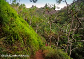
The Nualolo Trail descends through moist forest and then dry shrublands to a precipitous terminus at Lolo Vista Point. Prepare for a fairly challenging day hike. From the trailhead road, you jump up to the left and then climb steeply for the first .25-mile, entering the Kuia Natural Area Reserve. From the area reserve you drop steadily through forest with the occasional clearing. Birds love it here. The descent continues, as forests give way to open areas, home to koa trees, ginger, ferns. The trail swerves, making a left bend and then back to the right again as you descend a broad ridge top. About 2 miles in, you’ll get the first blue-water views. At almost 3 miles from the trailhead, you enter the Napali-Kona Forest Reserve, as the trail drops steeply down a knob to drier, eroded relief.
Your route continues straight out the bench, descending steeply, and coming to the Nualolo Cliff Trail junction, which is the connector to the Awa‘awapuhi Trail. The last .5-mile of the Nualolo Trail is the big thrill. The trail drops down an eroded slope and onto the curving lip Nualolo Valley—a 2,000-foot free-fall to your right into a big bowl. Fortunately, the fall to the left into Kawaiula Valley is not as sharp, and you can lean that way. The bench at Lolo Vista Point broadens out, with only dwarf flora in the vicinity, and it has a sturdy railing. Several Napali ridges provide views north and south. The rugged beach below where Nualolo Valley meets the Pacific is Napali Coast State Park, Be Aware: The earth is crumbly on the valley rim. There are places where people venture beyond the railing, but stay well back of edges.” – from the Kauai Trailblazer guidebook, 2011

Soul Surfer rides up the charts
Our Kauai Photo of the Day caught Bethany Hamilton riding one of her favorite waves. We’re keeping the exact site private. Her inspirational movie, Soul Surfer, is number five at the box office… Continue reading

Hawaii Big Island Photo of the Day
Take a walk on the wild side at Volcanoes National Park on the Big Island of Hawaii. Iki Crater trail is one of the park’s best. Be sure to check in at the… Continue reading
Kauai Hiking Photo of the Day
The Sierra Club rates this route as one of the most beautiful hikes in the world. It’s eleven hot miles to the end so bring plenty of water and energy bars. Apply for… Continue reading
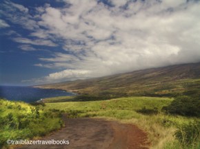
Kaupo Coast, Maui
excerpt from Maui Trailblazer guidebook: “Begin early morning. Take Highway 37 past Kula and continue as it becomes Highway 31. For many visitors the Kaupo coast will be Maui’s most pleasant surprise –… Continue reading